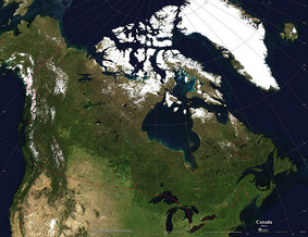
I was recently on the hunt for edu-apps for next year’s home-schooling extravaganza, and as Regions of Canada is one of the Social Studies topics for Grade 4 (Alex and Simon will be in grade 4 next year), I decided to look for relevant Canada Map apps.
While US map learning apps abound, Canada appears to be a more elusive market. The following three apps offer Canadian geography seekers and opportunity to learn…
While US map learning apps abound, Canada appears to be a more elusive market. The following three apps offer Canadian geography seekers and opportunity to learn…
GeoExpert by JarvApps offers an interactive map of Canada and the US.
I focused on the Canada app.
This app offers a practice mode and a test mode, to learn both provinces/territories, and capital cities. In the practice mode, one simply clicks on a province or territory, and its name (and capital, if selected) is revealed.
The test mode allows users to test their knowledge: The name of a province, territory or capital city is revealed, and the user must click on the correct location. If the user clicks correctly, the province is coloured in green. If the first guess is incorrect, another chance is given. (A subsequent incorrect guess makes the correct location flash on the map, so it can be found, thus consolidating the correct answer.) A small visual scoreboard tracks correct (green/thumbs up), one chance (yellow/thumbs up) and incorrect (red, thumbs down) responses.
GeoExpert Canada/US is a simple app, for learning only locations, but it allows young children to quickly learn the names and locations of provinces, territories or states and their capitals in an easy, intuitive manner.
My Geography is the next app I tried out, and it offers a few more learning options than the previous app. Although this app covers the whole world, I decided to focus on North America, and specifically, Canada.
From the Canada menu, players have the option to select not only Territories and Provinces, but also Capital Cities, Coat of Arms, Rivers and Lakes and Cities in general. Each option include three further options: "Learn", "Homework" and "Exam".
Within the “Learn” subsection, players can simply read a labled map, or click the “practice” button at the bottom of the screen to find a map with hidden labels. (This enables players to guess the correct answer, then click on the province, city, lake, or whatever they are practising, to reveal the correct answer). The “Exam” subsection allows players to test their knowledge: A name is revealed at the top of the screen, and when the correct province (or lake, city, river, etc.) is touched, a green dot and a happy face appear. Incorrect answers result in the correct location making itself visible, so that the correct answer is reinforced.
The app is fairly intuitive, and covers all the basics as well as a few extras. I really like that it includes rivers and some cities beyond the capitals. It’s also an app with enough options to offer a bit more engagement than some of the more basic Canada map apps out there, without being overwhelming. My kids could definitely figure this one out!
One enhancement that would take this app to the next level is the inclusion of photos of the locations when clicked on during practice.

| 
| 
|
The third and final app I investigated was iLearn Canada by Jumper Mobile.
I have to say that the first thing that struck me about this app was how clean and crisp the graphics looked. The app is also easy to navigate. Three main options exist in the menu: Learn, Game and Test.
Learn takes the user to a map of Canada, surrounded by labelled bodies of water and adjourning countries, which are also labelled. Clicking on a province or territory brings up that region’s short form name accompanied by a child’s voice pronouncing the full name. In this view, users are also given the option to click “learn more” about any province or territory; doing so brings up a window with an icon the that region’s flag and coat of arms, along with additional info such as the capital city, date of confederation, and official languages.
The Game option presents users with the same map, but this time, the names of provinces and territories appear at the top of the screen and are spoken aloud, and the user must click the correct location. At the end of the game, a scorecard appears indicating how many correct and incorrect responses there were. Bonus marks are given for how quickly one responds. (Don’t love this feature… it’s really my only complaint about the whole app – I wish there were a way to turn off the timer, it just stresses me out, and the research indicates that timed tasks rarely help students learn, and in fact, often hinder learning.)
The third menu option, Test, is similar to Game, but this time users are given multiple chances to find the correct location, and there is no annoying timer! Incorrect responses are labelled with the proper label, reinforcing the correct name of each province an territory, so it’s a test that still teaches.
All three apps are fairly easy to use, and will provide a good starting point for my students to learn the names and locations of "main" parts of Canada -- would love to see similar apps that deal with physical regions, or specific provinces, in order to help us learn about Canada in more detail.

 RSS Feed